Lesson Plans
Put the VT to work in your classroom
The Continents and Oceans of the World

Lesson Question:
How can students use the Visual Thesaurus and mnemonics to help them identify and memorize the continents and oceans of the world?Applicable Grades:
3-8Lesson Overview:
In this lesson, students use the Visual Thesaurus to help them identify and label the continents and oceans on a world map. Then, students create original mnemonic devices to help commit the lists of continents and oceans to memory.Length of Lesson:
One hour to one hour and a halfInstructional Objectives:
Students will:- define the terms continent and ocean
- use the Visual Thesaurus to identify and label the continents and oceans on a world map
- understand the concept of a mnemonic device
- create original mnemonic devices to help memorize the continents and oceans of the world
Materials:
- student notebooks
- white board
- computers with Internet access
- a globe
- a world map
- "Continents and Oceans of the World" sheets (one per student) [click here to download]
Links:
- http://visibleearth.nasa.gov -- a Web site sponsored by NASA that contains fascinating images and animations of earth
- http://nationalgeographic.com/xpeditions -- National Geographic's Web site that is an excellent resource for exploring different aspects of world geography
- "Mnemonics: Memory Builders," an excerpt from Fisher and Frey's Learning Words Inside and Out
Warm-up:
Observing the earth from a satellite's perspective:
- If possible, display an image of the earth taken by satellite. (A good site for finding such images is Visible Earth, a catalog of NASA's images of the earth: http://visibleearth.nasa.gov/.)
- Ask students to describe what they see from the perspective of a satellite, and briefly discuss how perspective shapes our views of the earth. How does viewing the earth from a satellite differ from viewing the earth from its surface?
- Show students different representations of the earth that can be found in your classroom. Explain that a globe is a three-dimensional representation of the earth and that a map can only display the earth's features in two dimensions.
Instruction:
Defining continent and ocean with the Visual Thesaurus:
- Have students describe what they can observe about the earth's surface from a satellite's view, and establish that both land and water cover the Earth's surface.
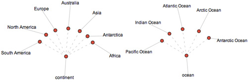
- Display the Visual Thesaurus word map for continent and click off the adjective definitions of the word (by clicking the "off" button next to the adjectives in the meaning list).
- Hover your cursor over the red meaning bubble defining continent as "one of the large landmasses of the earth." Explain that the different land masses on the earth that are visible from a satellite's perspective are called continents.
- Display the Visual Thesaurus word map for ocean.
- Hover your cursor over the red meaning bubble defining ocean as "a large body of water constituting a principal part of the hydrosphere." Explain that the major bodies of water on the Earth make up what man has designated as the five oceans of the world.
Discovering the names of the continents and oceans with the Visual Thesaurus:
- Display the word maps for continent and ocean and model how clicking on the definitions of these words as "one of the large landmasses of the earth" (continent) and "a large body of water constituting a principal part of the hydrosphere" (ocean) will reveal lists of the continents and oceans of the world.
- Point out in the continent display the names of the continents that are commonly considered as the seven continents of the world, i.e., Africa, Antarctica, Asia, Australia, Europe, North America, South America.
- Point out in the ocean display the names of the oceans that are commonly considered as the five oceans of the world, i.e., Arctic, Antarctic (also known as the Southern Ocean), Indian, Atlantic, Pacific.
Identifying continents and oceans on a world map:
- Organize the class in small groups and distribute a "Continents and Oceans of the World" map [click here to download] to each student.
- Explain to groups that they will be using the Visual Thesaurus and other online databases to help them identify and label the seven continents and five oceans on their maps.
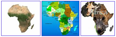
- Model the process of identifying and labeling a continent or ocean by reading its Visual Thesaurus definition and then by electing to "search images" in the drop down menu that is revealed by right-clicking (control/clicking on the Mac) on a continent or ocean's name.
- For example, if one chooses the "search images" option while right-clicking on "Africa" in the continent display, students will see images of the African continent and will then be able to correctly label it as Continent #3 on the sheet.
Introducing Mnemonics:
- Have students self-assess their completed maps by conducting a review of the continents and oceans' names and locations on a class globe or map.
- Explain to students that a fun way to commit the lists of the continents and oceans to memory is to independently create a mnemonic for each list. A mnemonic is commonly a phrase or sentence made up of words that begin with letters that are representative of items on a list (To learn more about the use of mnemonics, read the Frey and Fisher Book Nook excerpt "Mnemonics: Memory Builders.")
- For example, a mnemonic for remembering the oceans' names in the order from smallest to largest is:
Aunt (Arctic)
Sally (Southern)
Is (Indian)
A (Atlantic)
Pip (Pacific)
Wrap-up:
Developing mnemonic devices to help students memorize the continents and oceans' names:
- Explain to students that if they make up their own mnemonics for the two lists they will be more likely to remember them well due to the personal connection they will have to the memories. For example, if a student does not have an Aunt Sally but is an Arnold Schwarzenegger fan, he or she may more easily remember the mnemonic for ocean names as "Arnold Schwarzenegger is a politician."
- For homework, assign students to develop their own mnemonics for remembering the names of the seven continents and five oceans.
- In a subsequent lesson, have students share their original mnemonics with one another orally or in a classroom display
Extending the Lesson:
- To expand students' research of the continents and oceans of the world in a creative format, you could have students write short stories involving characters that begin their adventures or journeys in one continent, then travel across at least one ocean to reach another continent. Students would of course need to research the geography and cultures of the continents in which their stories are to be set and incorporate some of those elements into their tales.
Assessment:
- Check whether or not groups accurately identified the seven continents and five oceans on their "Continents and Oceans of the World" maps.
- Assess students' mnemonic devices to see if they can be used to recall the names of the continents and oceans.
Education Standards (MCREL):
Geography
Standard 1. Understands the characteristics and uses of maps, globes, and other geographic tools and technologies
Level I (Grade K-2)
Benchmark 1. Understands the globe as a representation of the EarthKnowledge/skill statements
1. Know the characteristics of a globe
2. Know how land is represented on a globe
3. Know how water is represented on a globeLevel II [Grade 3-5]
Benchmark 1. Knows the basic elements of maps and globes (e.g., title, legend, cardinal and intermediate directions, scale, grid, principal parallels, meridians, projection)Knowledge/skill statements
1. Knows the basic elements of maps
2. Knows the basic elements of globes
3. Understands the concept of a titleBenchmark 2. Interprets topography using aerial photos and maps
Knowledge/skill statements
1. Interprets topography using aerial photos
2. Interprets topography using mapsLevel III [Grade 6-8]
Benchmark 1. Knows the purposes and distinguishing characteristics of different map projections, including distortion on flat-map projections
Knowledge/skill statements
1. Knows the purpose of different map projections
2. Knows the distinguishing characteristics of different map projections
Standard 2. Knows the location of places, geographic features, and patterns of the environment
Level II [Grade: 3-5]
Benchmark 3. Knows the approximate location of major continents, mountain ranges, and bodies of water on Earth

